The best way to see the seven sisters
is by road but one needs to plan properly. Unlike other places a fair amount of homework on road connections, bridges and ferries is essential. Survey of India maps is dependable and accurate and they must be carried without fail. Guwahati could be a good starting point, and one can get there by train or by air or drive in. it is possible to opt for travel via the rivers if a lot of time is available - the experience would be unforgettable.GENERAL INFORMATION
BEST SEASON: Every season holds its own splendour in the eastern states. In fact, even within them each of the seven sisters has a different face to show. However, for the time bound traveller, it is best to avoid the months between June and September when the monsoons turn large areas in this region into vast stretches of water.
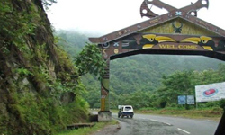
October to March is the best months though winter rains do visit the area in December and January. If you plan a visit to Tawang in Arunachal Pradesh, then mid-September to November and March-April are good periods because in peak winter you may get held up at Sela Pass or at least have difficulty crossing the pass.
WHAT TO CARRY: Diverse encounters are to be expected. Temperatures will vary. Shillong or Ziro or Tawang or Aizawl can be cool at any time of the year therefore woollens are necessary. It can also rain anywhere, any time so an umbrella is a must. A fair amount of walking has to be done so comfortable walking shoes are needed and one needs to be generous with socks. Forests or heavy vegetation reminds you to carry mosquito repellents and salt to get rid of leeches. Clear days can be quite relentless so a straw hat is a good idea. Carry a few plastic bags for wet clothes. A rucksack and a sleeping bag give you the option to take off on treks. For camera equipment and film rolls, carry plastic bags and silica gel. If your camera uses batteries it is better to carry some spares.
PERMITS: Arunachal Pradesh, Mizoram and Nagaland would require inner line permits. They are available at Kolkata, Delhi and Guwahati tourist offices though the local administration also has the authority to give it to you.
HOW TO GET THERE: Most of the areas are not connected by rail. One has to travel by road most of the time. While roads are generally good, there are steep climbs, sharp bends and the occasional rough tracks. One can see much more by road and stop where one likes to frequently. If you plan to travel in your own car, test your engine, brakes and carry enough spares like fan belts, fuses, wires, etc.
Arunachal Pradesh
 The Land of Rising Sun: Early riser, Arunachal, the land of the rising sun, is the remotest and one of the loveliest region, yet most scantily populated state in the entire North East. Arunachal is a unique holiday destination. Its hunting beauty has a magical charm that lures the visitors to imbibe of its natural beauty, tribal culture, craft traditions and splendid wildlife.
Arunachal shares borderline with China (Tibet) in the north, Myanmar (Bhutan) in the east, Bhutan in the west and the states of Nagaland and Assam in the south. Its fertile lands are watered by five major rivers, primary amongst them being the river Siang (starting as the Tsangpo in the Mansarovar in Tibet) fed by thousands of river and streams en route through Arunachal is the mighty Brahmaputra river of Assam.
Largest of all the North Eastern states (83,743 sq km), Arunachal is blessed by a delightfully variegated climate perfect for holidays any time of the year. Almost 80 per cent of the state is under forest cover, which varies from the sub-tropical to the alpine in the upper region of the northwest, where it is bordered by the Himalayan ranges. The vast canopy of rainforest with its dynamic bland of an amazing plethora of flora and fauna is one of the world’s 17 bio-diversity heritage sites. Its serried peaks, running from north to south, are interspersed with rich valleys in whose hidden folds live her ancient tribes in their picturesque villages. Strung out along the misty hilltops and deep valleys, its picturesque townships and villages are the first in the land to be kissed by the rays of the morning sun giving Arunachal its unique position as literally “the land of the rising sun.”
Itanagar:
 The land of the Dawn lit Mountains, Itanagar; the capital of Arunachal Pradesh is also its biggest town. The Jawaharlal Nehru Museum has archaeological finds from Ita Fort to which one can trek up. Housed here are also an interesting collection of arts and crafts, jewellery, textiles and a verity of tribal headgear, which gives u an insight into Arunachal’s tribal cultures. Try the local brew Apong, a rice beer that’s drunk warm. Your night stumbles upon some of the Nyishi tribal who live around here. You’ll recognize them by their massive knot of hair rolled into a bun over their forehead. In their headdress they wear feathers of the great hornbill, Arunachal’s signature bird. Shop at the craft emporium for local mementos. Just 6 kms away is the picturesque setting of Ganga Lake (Gekar Sinyi).
Bomdila
 The district headquarters of West Kameng, Bomdila is a delightful stopover amidst apple orchards, lush green forest and trekking trails where time seems to stand still. There are a couple of picturesque gompas here and the craft centre has a delightful range of hand woven carpet woven by the local Monpa tribes. This is also a home to the gentle Sherdukpen tribes. Nearby Dibang is famous for its pretty gompas and colorful Kalchakra celebrations. If you your visit doesn’t fit in with its timing do visit the yak breeding centre can be quite enlightening. Enjoy a dip in the enervating waters of the local hot spring in verdant surroundings. Famous for its apples. It has also started kiwi cultivation. In the winter, you’ll spy the black-neck crane of Ladakh here. As you climb to the higher reaches of mountain road to Tawang, the forest thins out and air becomes increasingly colder.
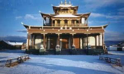
Tawang:
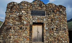
 With it’s centuries-old great fortress monastery against the dramatic setting of the snow-mantled peaks. Tawang is accessible by car in a dramatic drive through mesmeric alpine country. The sinuous road to Tawang passes through the dragon gates on the awesome heights of the great Sela Pass (13,714 ft.). Jaswantgarh located here is a memorial to the brave soldier who single-handedly tried to hold of approaching Chinese from the Pass during the 1962 Indo-Chinese war. The stupa-like Tawang War Memorial also salutes the heroes of the war.
There’s strong Tibetan presence in Tawang. Prayer flags flutter in the breeze. Monks in their soft robes slip silently through the market square attending their daily chores. There are 500 of them attached to the great monastery on its dramatic perch on the spur, a short distance from the main town. It is supposed to be the biggest monastery after Lhasa’s Potala. The current Dalai Lama is said to have passed through the township on his escape from Tibet. The Urgelling Monastery here is also associated with the birth of the 6th Dalai Lama. It’s features his preserved footprints and fingerprints, which are much revered by Buddhist devotees.
The great Tawang Monastery, with its dramatic background is eye-catching. A stunning 8 meters high glided statue of Buddha dominates the sanctum. The great rotating prayer wheels, priceless tangkhas, the drone of the monks in prayer sputtering butter-lamps are an evocative vision. Its assembly hall is massive & three stories high. Attached to the monastery is a library with priceless manuscripts, scriptures and literature; there’s a school, huts for the monks and a great community kitchen. Its museum has rare and beautiful tangkhas and ritual vessels amongst other important artifacts, including some possessions of the 6th Dalai Lama.
The craft centre in Tawang sells beautiful masks, hand-woven carpets, tangkhas, jewellery in silver, turquoise, coral and amber, chubas the local dress and delightfully affordable mementos.
Ziro:
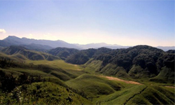
 Picturesque Ziro is 200 km from Itanagar. Situated on the Apatani Plateau (in the lower Subansiri region) and surrounded by pine mantled hills all around, it is spectacular. It’s a tourist delight with its dazzling landscapes and tribal culture. Make a point to visit Tarin, the-high altitude fish firm, the famous whispering pine grove and the craft centre. From a hilltop, catch the first rays of dawn lighting up the stunning emerald patchwork quilt of nature.
A visit to an Apatani tribal home is a must. The Apatanis are one of the most advanced and intriguing of Arunachal’s tribal people. Both men and women tattoo themselves and the women are distinctive with their great nose plugs (dat) made of bamboo and face tattoos. It has now been banned. The Apatanis grow rice by terrace farming; they also have created an indigenous irrigation system which is unique amongst the Arunachal tribal. The village comprises of long rows of houses with a fertility totem in front of each one. In their cooking, they use an indigenous herbal salt that’s rich of iodine. Living in perfect harmony with nature, for every tree they fell, five fresh saplings are planted. The weaving skills of their women are legendary as can be seen from the wonderful Jikhe pattern, woven jackets and intricately patterned Jilang shawls. The men are skilled in metallurgy and bamboo craft. It is well connected by bus to Daporijo (home of the Tagin and Miri tribes), the districts headquarters of upper Subansiri.
Pasighat:
 Situated at 155 meters with its scenic splendors, Pasighat is Arunachal’s oldest town and also the district headquarters of East Siang. The turbulent Siang River races across the district heading for the plains, where it is meet by the Dihing and Lohit rivers, and than roars into Assam as the mighty Brahmaputra. The region is the home of the Adi tribe who are remembered for their colorful Ponung dance. Pasighat is also ideal for adventures sports activities. The Dying Erring Wildlife Sanctuary is 13 km away and is worth visiting. The archaeological site of Milinithan (100 km) is linked to the legend of 6 Lord Krishna and his wife Rukmini. The dismembered head of Sati (Parvati) is said to have fallen at Akashiganga (100 km) according to ancient Hindu myth. This is a sacred place for Vaishnavites.
Namdapha Wildlife Sanctuary:
 Sharing borders with Myanmar, Namdapha is home to one of the most unusual and most significant wildlife sanctuaries in India. Its vast biodiversity supports a fabulous range of endangered flora and fauna and avian life. Its altitudinal variation is truly unique, ranging as it does from the sea level of the valley floors, to snow-covered peaks at heights of 4500 m. the climate here ranges from tropical to the extreme cold all year around in its higher reaches. Namdapha is accessible from Dibrugarh via its entry point Miao, 112 km away. This unique sanctuary is the natural habitat of all four great cats. Namdapha is the only natural habitat where u will find presence of tiger & the leopard. Here you see the clouded leopard and the snow leopard. It is also home to the endangered Takin, Hoolock Gibbon, Red Panda and Capped Langur. The sanctuary has 150 species of trees and has a fabulous wealth of medicinal and ornamental plant life. Much of its immeasurable botanical bounty has not even been surveyed because of its inaccessibility. Amongst its immense range of avian denizens is the great Indian Hornbill, the state bird of Arunachal. Best time to explore Namdapha Wildlife Sanctuary is in winter. You can stay at picturesque Deban Ghar Bungalow overlooking Noa Dihing River.
Tripura - Land of Cultural Synthesis
 The beauty of the erstwhile princely state of Tripura stems from the splendor of its natural setting and its dazzling heritage. Its verdant expanses and rich forestlands have been a great attraction to people down the centuries and for tourists down the decades. It offers a plethora of delightful attractions in its cavalcade of historic palaces; rock cut carvings, stone sculptures, Buddhist and Hindu holy places, wildlife sanctuaries and tribal people.
The princely state of Tripura acceded to the Indian Union in 1949. it is an ancient land of mysterious past and located in the North Eastern region of India and is bounded on the North, West, South and South-East by the international boundary of Bangladesh. In the east it has common boundary with Assam and Mizoram. 60 percent of the total area is under hills and forests with elevations progressing gradually from 100 ft. – 3000 ft. from southwest to northeast. Pollution free eco-friendly environment and pleasant weather of this panoramic tiny state is inhabited largely by 19 tribes. Reangs, who came in from Chittagong, are the second largest amongst the tribes living in the state. Other tribes include the Jamatia, Noatia, Darlong, Halam, Garo, Chakma and Kalai.
Tripura represents a composite culture with several ethnic groups residing in the state. Through the cultural heritage of one community differs from the other but the manifested efforts have mingled them into a single whole giving birth to a unique cultural genre. Tripura can be termed as a laboratory of exotic culture synthesis.
A matchless combination of age-old culture and tradition is reflected in the beautiful handloom and handicraft products of the State, which attract the visitors for its classic actuality, exquisite colour, excellent design and craftsmanship.
Agartala
 Agartala, the state capital of Tripura, it set amidst vast expenses of tranquil beauty making in an ideal base for exploring the ancient palaces, temples, lakes and wildlife sanctuaries of this erstwhile princely state. But take time off to explore the city’s own charms.
Ujjayanta Palace,
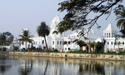 the famous royal house which stands at the heart of the city within a compound covering an area of one sq km was built by Maharaja Radhakishore Manikya in 1901 which is set with the huge Mughal style gardens, beautified by pools and fountains, the magnificent tiled floors, curved wooden ceiling and beadful craited doors. Flood lighting and fountains have also added to its beauty.
Jampui Hills:
 the entrancing verdure of the Jampui Hills (the premiere hill range of the six in Tripura) is enhanced by its bracing climate, giving visitors reason enough to call them ‘the seat of permanent spring’. Clamber up those gentle heights to enjoy panorama tinged by spectacular sunrise and sunset. Jampui is home to some very exotic species of orchids, ornamental trees and fragment orange groves. The abundance of oranges has in fact, given wing to the Orange Festival held in November when the surrounding hills are heavy with the fruit and a riot of colour. The cobweb of picturesque trekking trails, punctuated by friendly brooks and serene lakes along the Jampui Hills, are a treat for the outdoors enthusiast.
Village tours are becoming increasingly popular, as the Lushai and Reang (of Mizo stock) community here is welcoming and hospitable. It’s magical in the monsoon too. Especially when the gentle mist lifts intermittently to reveal pretty vignettes of the hunting views of neighboring Mizoram in the distance.
Kamalasagar Kali Temple,
 was built on a hill-top by Maharaja Dhanya Manikya in the late 15th centaury. It is situated just beside the Bangladesh border, 27 km from Agartala. Pilgrims from around the country and nearby Bangladesh converge annually at the temple in the months of April and August to celebrate the temple deity Goddess Kali. Its tranquil, pollution-free environs and natural setting make Kamalasagar an ideal holiday escape for tourists.
Udaipur:
 Udaipur, situated on the banks of the river Gomti, is a city of lakes and palaces. The remains of a dilapidated palace on the northern banks of the river are a remainder that is small town (today the headquarters of the South Tripura district) was once the seat of the Manikya dynasty rulers. Udaipur has a string of popular lakes such as Jagannath Dighi, Mahadev Dighi, Dhani Sagar, Amar Sagar and kalian Sagar, apart from Lake Rudrasagar.
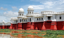
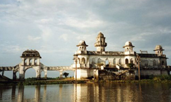
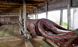
Neermahal:
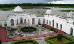 At Udaipur, Tripura’s lovely lake palace on Lake Rudrasagar, Neermahal, is Eastern India’s only water palace. The palace was the dream castle of Raja Bir Bikram Kishor Manikya Bahadur, who quite obviously had keen aesthetic sensibilities. Built in 1930, this floating castle took nine years to be executed to his specifications of luxury and beauty. A blend of Hindu, Muslim architecture, and about 400 m in length, the maharaja’s summer resort has 24 rooms with provisions for private quarters (Andarmahal) for the king and his family and retinue the servants. It also had a dance hall and an assembly hall where he could meet people. The tracts of green fields edging the lake come alive with birdsong during the annual arrival of the migratory birds. Access to the palace was by boat, which led directly to the rooms. Nirmahal is 55 km from Agartala.
There’s boat festival held at the lake annually. Visitors can stay at the picturesquely located Saharamahal tourist lodge at Rajghat, the access point for the palace from which you can get a boat. Another attraction here is the craft and heritage village.
Tripurasundari:
 One of the most important and much venerated attractions of Tripura is the ancient temple of Tripurasundari located on a hilltop 3 km from Udaipur, 55 km from Agartala. Matabari (Mother Goddess) is regarded as one of the 51 piths (holy sites) of Hindu pilgrimage. Goddess is an avatar of Parvathi, the Consort of Lord Shiva, the principal deity of the State. A curious legend surrounds its origins. Tripura’s King Dhanya Manikya of the 15th century is said to have had a dream ordering him to establish Tripurasundari at this hilltop temple. But the king knew that it was already dedicated to the Lord Vishnu and he knew he could not obey the signs in the dream, because Lord Vishnu and the consort of Lord Shiva could not share the same abode. But the divine command was repeated to him the next night. Giving in the king did as he was bid.
The Kalyansagar Pond that he built close by is home to tortoises that are deeply revered by the devotees of the temple. This venerable temple is also referred to as the Koorma (tortoise) Pith. The temple is 500 years old. Diwali is celebrated with great pomp here.
Bhubaneswari Temple
 Adjacent to the palace ruins lays the old Bhubaneswari Temple – one of the oldest temples in the state, located on the bank of river Gomti. Bengal’s most famous luminary, the Poet Laureate Rabindranath Tagore in his famous drama Bisrajan and his novel Rajarshi immortalized the temple. The site is the great attraction for tourist from Bangladesh and West Bengal. Another interesting temple in the vicinity is the Jagannath Temple. On the hills facing the river are the Chabimura rock panels. Carved into the hillside are images of Shiva, Vishnu, Kartik, Mahisasur and other deities, said to belong to 15th – 16th century.
Unakoti:
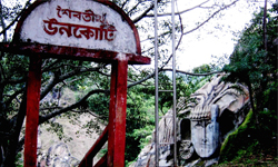 Unakoti 178 km from Agartala, is deservedly reputed for its 7th – 9th century stone and rock cut images, deep in the forest near Kailashahar. The worship of Shiv – Shakti (Shaivism) is an old tradition in Tripura and this is beautifully endorsed by the 30 ft. high Shiva head (the Unakotiswara Kal Bhairava) with an embroidered headdress which forms part of one of the largest bas-reliefs in the country, at Unakoti. On either side of the headdress of the central Shiva are two life-size female figures. Three enormous images of the Nandi bull lie half buried in the ground. Legend has it that Lord Shiva on his way to Kashi, present-day Varanasi, with a core of gods and goddesses stopped at Unakoti for the night. Before retiring for the night he instructed them all to wake up before sunrise to continue on their journey. Finding he was the only one up at the prescribed time Lord Shiva left in the rage, turning his companions into stone images with a curse. There is thus one stone imageless amongst the core that you will find at Unakoti. The annual Ashokastami Mela is held here in March/April.
Dumboor
 Dumboor, with a water area of 41 sq kms with an unending spell of luxuriant green vegetation all around stands majestic for her exceedingly charming beauty. There are 48 islands dotting in the lake which is home to numerous birds of all shapes and colours. During the migratory period, the lake becomes a picture of hectic activity amongst its avian denizens. You can also take a boat ride around this petty lake. Water sport facilities including boating facilities and variety of wildlife is an additional attraction.
Pilak
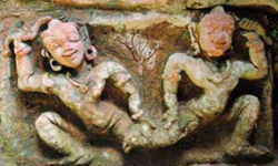 Pilak is a palace of attraction for its archaeological remains of eighth/ninth centuries, located at a distance of 100 kms from Agartala. Number of terracotta plaques, sealing with stupa and stone images of Avolokiteswara including images of Narasimhan have been found there which date backs to Buddhist period. The place has close association with Mynamoti and Paharpur in Bangladesh. Recently, further excavation has been taken up by Archaeological Survey of India.
Sipahijala Wildlife Sanctuary
 The vast colony of residential and migratory birds makes Sipahijala Wildlife Sanctuary a lively attraction for birdwatchers. Just 30 km away from Agartala, it covers an area of 18.53 sq. km. in addition of this, its orchid garden and botanical garden unfailingly lure the visitors who came to enjoy a spin around the lake in a boat or take a joy ride in a toy train. It’s ideally located to soak in those spectacular views of the coffee and rubber plantations. There are a few tourist cottages in the sanctuary.
Trishna Wildlife sanctuary
 The bison and great residential and migratory bird population are the great attraction for the visitors at the Trishna Wildlife sanctuary, situated about 100 km from Agartala. It is also home to the Hoolock Gibbon, Golden Langur and Capped Langur.
Nagaland - Veritable Paradise of Fun & Festival
 Nature could not have been kinder to Nagaland, sometimes referred to as the ‘Switzerland of the East’; the exquisitely picturesque landscapes, the vibrantly colourful sunrise and sunset, lush and verdant flora – that is a land that represents unimaginable beauty, moulded perfectly for a breathtaking experience. It is a land of song and music where you can hear flock songs praising the brave deeds of ancient warriors and folk heroes; loves songs immortalizing tragic love stories, gospel songs and modern tunes.
Nagaland was inaugurated as the sixteenth State of India on 1st December, 1963. It is bounded by Assam in the west, Myanmar (Burma) on the East, Arunachal Pradesh and parts of Assam on the North and Manipur in the South. The state consists of eight Administrative Districts, inhabited by 16 major tribes along with other sub-tribes. Each of the sixteen odd tribes and sub-tribes that dwell in the exotic hill state can easily been distinguished by the colourful and intricately designed costumes, jewellery and beads that they wear. The present generations of Nagas have ventured into fashion designing in a big way, reproducing fabrics that represent the ancestral motifs blended with modern appeal. Indeed, it is a beautiful mix of the past with the present a paradise for those who are into fashion designing.
Nagaland is blessed with a salubrious climate throughout the year and one can visit it anytime. If one is looking for a quiet get away from the hectic city life, it provides the right ambience; for life is laid back and slow here – providing a tension free life. For the adventurous and the intrepid, Nagaland is an ideal place for trekking, jungle camping and offers limitless exploration possibilities in its lush and verdant sub-tropical rain forests, which are also a treasure trove of plethora of medicinal plants. Nagas, by nature, are lovers of fun and festivities and life is one long festival. Above all, here the people are warm hearted and extremely hospitable! You will feel it in the air.
Dimapur :
 Dimapur is situated at an altitude of 145 metres above sea level. It is the gateway of Nagaland. This fast developing town is also the commercial. Centre of the state, which is connected with the main broad gauge railhead. Dimapur has the only airport in Nagaland. Indian Airlines plies four flights a week to Dimapur. The National Highway 39 passes through the heart of the commercial centre of the state.
The ruins of medieval Kachari Kingdom:
the ancient Kachari capital Dimapur is one of the important sites of megalithic culture. Most of the ruins appear to be contemporaries with the Kachari civilization, established before the Ahom invasion in the 13th Century AD. There are evidence of a touch of Hindu influence on most of them, though these are predominantly Non-Aryan, with elaborate rituals and the cult of fertility. Besides the monoliths, the ancient Kachari capital Dimapur contains other ruins of temples, embankment and tanks. The entrance gateway has been beautifully executed and is in good preservation till the present time. There are still scattered blocks of stone and back pieces with various designs.
Kohima:
 Located at a high of 1495 m is Kohima, the state capital. A pretty town it is endearingly unspoiled, tranquil and immersed in history. The World War II Memorial, listing the brave Nagas who laid down their lives, is the biggest attractions here. The State Museum showcases in dioramas, some of the most fascinating aspects of Naga tribal life in all its variety and wealth of tradition. Housed here is ancestral weaponry, carved gatepost, status pillars that record Feasts of Merit and traditional Naga costumes and jewellery.
The picturesque Kohima War Cemetery, a symbolic memorial commemorating the memories of the officers and men who sacrificed their lives (regardless of race, nationality or religion) during World War II, is a must visit. Well-maintained by the Commonwealth War Graves Commission, and steeped in tranquility, it is embellished by two tall crosses against the backdrop of seasonal roses and lush grass. The gentle hill where the cemetery is located is embellished by stone markers with shining bronze plaques, each one commemorating the name of the men who sacrificed their lives.
The State Museum has a rare collection of artifacts of the different tribes, which inhabit the state. It depicts the different aspects of life of the people in all its varied forms. A must see for getting an idea of the people’s lives.
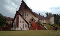
The Catholic Cathedral at Aradurah hill is an important landmark at Kohima. It is the largest Cathedral in the whole North East and it quiet and serene ambience is conducive for meditation and prayer. It has a blend of the indigenous and modern architectural styles.
Kohima Village, called Barra Basti (Big Village), is where Kohima began, according to Naga legend. Said to be the second biggest village in Asia, it has one of the finest ceremonial gates, common to all Naga villages. The beautiful carvings of warriors and guns, and the symbol of prosperity, the mithun, heighten the importance of the Naga gateway. As you enter this village, you notice a number of gates with traditional wooden gates with the scimitar of horns of mithun. These motifs indicate the bravery and valour of the Angamis. In this village, one comes across wooden curving looking like horns atop some houses. One also see relics of stone erections here in there in front of the houses which are memorial the grand feasts offered by their ancestors.
Khonoma:
 This village, which lies 20 km West of Kohima, was known for its fighting prowess in the past. It is also known for the fallow management of its alder trees, which balances nature in the surrounding areas. The beautiful terraces, which are carved out of the hill slopes surrounding the village, are a sight to behold. These terraces grow over 20 types of paddy at different elevations. Khonoma Nature Conservation and Tragopan Sanctuary was set up in 1998 by the ecologically conscious people of Khonoma Village. This sanctuary covers an area of over 70 sq. kms is privately owned and managed by the Village Community of Khonoma. This sanctuary is also the habitat of many other endangered and rare species of plants and animals. The sanctuary is also an ideal place for adventure and nature study.
Dzukou Valley:
This Valley otherwise called the valley of eternal charm has an irresistible appeal to all who behold it. Its emerald green rolling hills interspersed by gentle flowing streams are trekkers’ delight. It is tucked away at an altitude of 2,438.4 metres behind the Japfu ranges. It is about 30 km South of Kohima, half of which has to be approached through rough trekking. The serpentine streams that flow leisurely through Dzukou freezes during extreme winter. In summer, wild herbs and shrubs sprout along the stream banks. Lilies in white and pink, euphorbias, aconitums and hundreds of other species of flower and plants in varied colours adorn the valley in monsoon. Through Dzukou is known for its bio-diversity, the predominant plant is the tough bamboo brush because of which it looks like a fully mown lawn from far away. Rhododendrons of different colours ornament of hills surrounding the valley. This is one of the best trekking spot in the North-Eastern Region. In spite of the difficult terrain and nonavailability of facilities, this is one of the most frequented trekking spots in the entire North East India. A few tourist rest houses are constructed for trekkers.
Tuophema Village:
 This village which is 41 km. from Kohima has been chosen for the promotion of the common Angami Sekrenyi Festival celebrated during February 25 – 27 every tear. Sekrenyi is a festival of purification and revolves round rituals and ceremonies of cleansing the village well. It starts with all men – young and old – going to the village well for bathing in the morning. At night the well is cleaned by two youths and to ensure that no one takes water from the cleansed well, a night vigil is kept by the youths of the village. The next morning according to the demands of the ritual, all men rise early and bathe in the well. It is believed that the purified water washed away the diseases and misfortunes. Thereafter begins the festivities of the celebration which include singing, dancing and feasting throughout the day.
Japfu Peak:
 This is the second highest peak in Nagaland and stands 3048 meters above sea level. It is about 15 kms south of Kohima. The best season for climbing this mountain is from November to March. The sunrise from the peak is an experience to remember. From the peak one can have a birds-eye-view of the surrounding hills including parts of Dzukou Valley. In the Japfu ranges, one can find the tallest rhododendron tree, which is featured in the Guinness Book of World Records. This tree, which was first discovered by two professional hunters of Phesarna village, is over 109 feet tall and the girth at the base measures more than 11 feet. When it is in bloom, it is indeed a visual delight. It’s quite an adventure to see this tree as it entails more than five hours of strenuous trekking through steep inclines to have a view of this World Record holding Rhododendron arborea tree.
Mokokchung
 This is picturesque town is the headquarters of the Ao Nagas. It is situated at an altitude of 1,325 metres above sea level; Mokokchung is 162 km from Kohima via Wokha. One can have a beautiful view of Mokokchung town from the viewpoint at the Town Park. The main festivals of the Aos are Moatsu and Tsungrem Mong celebrated during the fist week of May and August respectively. The footprint of Jinaand Itiben – the Romeo and Juliet of the Aos are found on the rocks in several places in the Aos ranges.
Ungma
 This is the biggest Ao village and looks like an adjunct to Mokokchung town. According to legend, the early Aos settled here first after coming from Chungliyimti. This village is many centuries old and can be of interest to people who have a desire to peep into Ao folklores, customs and traditions.
Mopungchukit
 This village lying near Impur the permanent Mission Centre of Ao Baptist Arogo Mungdang (ABAM) is making attempts to revive the ancient Ao culture. Some efforts have been made to construct Morungs, carve the Time-Pillar and to preserve some artifacts in a village museum.
Chuchuyimlang
 This village celebrates Moatsu festival in a traditional way with exchange of gifts and friendship with other neighboring villages. The festival is celebrated in a colourful way with dance and song every year from May 1-3. Moatsu, the spring festival of the Ao Nagas is celebrated in all Ao villages, but is more spectacular in Chuchuyimlang. Dance and folk songs, indigenous games and tribal chants lend colour to the occasion.
Mon:
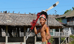
 Mon brings to one’s mind pictures of chiefs tattooed faces of konyaks and muzzle – loading guns which the ingenious Konyaks manufacture. It is 357 km from Kohima via Dimapur and 280 km from Dimapur, 275 km from Kohima via Mokokchung, Tamlu and Wakching. Mon headquarters, home was established at Chen and Mon village land being centrally located for the coronation of Anghs (Chiefs). Here, one can see the feathered headgears and traditional dresses. Konyaks are adept artisans and skilled craftsmen. Here we find excellent woodcarving, daos, guns, gun powder, head brushes, headgears, necklaces made by these artisans and craftsmen. It is an exciting experience to pay a visit to Angh’s house at Chui, Mon, Shangnyn, Sheangha, Chinyu, Wakching and Japoka. The most colourful festival of the Konyaks – Aoling Monyu is observed during the first week of April and is a spectacle worth a watch.
Shangnyn Village
ruled by the Chief Angh is a prominent village in Mon district. There is a wonderful wooden monument measuring 8 feet in height and 12 feet in breath – believed to be constructed by heavenly angles. Human beings and other creatures are curved on this monument. Memorial stones are also found in front of the Angh’s palace.
Longwa Village is one of the biggest villages in the district. As the village straddles the international boundary line, one half of the Angh’s house falls within the Indian Territory and the other half lies in Myanmar. An interesting feature of this village is that the Angh of the village has 60 wives and his jurisdiction extends up to Myanmar and Arunachal Pradesh.
Chui Village
is situated about 8 kms from the district headquarters of Mon. one can see some of the houses constructed in the true Konyaks tradition with palm leave roofing and the main pillars jutting out. Chui is also famous for things ethnic. The artisans and craftsmen of the village are not only good at bamboo and woodworks but are experts in gun and gun powder making.
Veda Peak
is the highest peak in the district which is about 70 kms East of Mon. From the peak; one can have a clear view of both river Brahmaputra and Chindwin on a clear day. There is a waterfall on the slopes of this hill. This is one of the best locations in the whole of Konyaks countryside.
Phek:
Home to the Chakhesangs and Pochuries, it is 145 km from Kohima. Colourful orchids grow wildly here. This area is also the habitat of Blyth’s Tragopan, a rare pheasant found in Nagaland. Chakhesangs are known for their wrestling and robust health. Their terrace fields curved out of the hill slopes are a sight of behold. It speaks of their engineering skills. The stones and pillars near Chesezumi on the Chazouba road tell tales of valour of the ancient Chakhesangs.
Pfutsero Township
built at an altitude of 2,133.60 metres is the coldest and highest town in the state. It is known for its green vegetables such as cabbages, spring onions and garlic’s. apples are also grown around this area. It is connected with Kohima by a 70 kms border road. Nagaland state transport buses ply on this road regularly.
Shilloi Lake
, which is shaped like a footprint, is also called Lacham. It lies on the slopes of the Indo-Myanmar water-shed in Phek District of Nagaland. The average depth of the lake is likely to be four metres but at places it is as deep as the length of full large size bamboo pole. In the past, the lake was believed to be the abode of spirits by the locals. And they wove many eerie tales around it. Therefore, they did not use the water for drinking or irrigation. Nor did they fish in it. But all those beliefs are gone and now they use the water. The water is dark grey, perhaps because of the silt adding to the mystery. Shilloi is about 300 km from Kohima and can be accessed by jeep, truck or bus via Meluri.
Tuensang:
 Located at 1,371.60 metres and at a distance of 269 km from Kohima via Wokha and Mokokchung and 235 kms via Zunheboto. Tuensang is small Nagaland with six different tribes: Changs, Yimchungers, Khiamniongans, Sangtams, Phoms and Semas. The tribes inhabiting the district are rich in cultural heritage and their dresses are very colourful. Their dances are rhythmic and songs are heartwarming. This area is known for its handicrafts and handloom products. Tuensang has its own old World charm and there are nearby villages where one can get a glimpse of the cultural tradition of the Changes in whose land Tuensang falls.
Monyu is a festival marking the end of the old year and beginning of the new. It also marks the end of winter and the beginning of summer. The beating of the log drum in a distinct way signifies the heralding of the festival. It is also a time of prayer and dedication for the seeds sown and are already sprouting. It is an occasion for the male members of the family to renew their affections towards their married daughters and sisters. They present them with the choicest rice beer and specially prepared food. Such conduct shows that Phom women are held in high esteem by their men folk and enjoy high status. Community planning and other decisions related to the community are also taken during this time. The village of Pongo as a festival destination of the Phoms.
Pungro,
the circle headquarters is only 36 kms from Kiphere. From here is takes three days of trekking to reach Saramati Peak, a part of which falls in Myanmar (Burma). However, since Pungro is out of the way, one can proceed to Salumi straight, and than, trek to Thanamir village and halt there (or to Fakim through Penkim route). The next day, one can trek up to the Base Camp (the last water point) and rest there. On the third day, one can climb Mt. Saramati.
Wokha:
Wokha is the district headquarters of the Lothas. It is equidistant at 80 m both from Kohima as well as Mokokchung. It is 58 kms from Furkating Railway Station (Assam). Wokha literally means census in Lotha. It was the place where the ancient Lothas counted heads before spreading out into the villages during their waves of migrations. There are monoliths (Longzu) erected by their rich ancestors to exhibit their status. Lothas are known for their colourful dances and songs particularly Shanta. Tokhu Emong and Pikhuchak are their main festivals. The former takes place on the seventh November every year. In the middle range, at Lakhuti village, one can find Tiyalong – a rock. It is believed that if the area around this rock is cultivated the drought occurs.
Mount Tiyi
is a hill with mysterious legends. It is believed by all Nagas that it is the abode of the departed souls. In local folklores, it is said that there once existed an orchard which could be traced by the lucky once only. Colourful Rhododendrons are found clasping the rocks and cliffs. The peak offers a panoramic view of the villages, hills and valleys.
Totsu, is a cliff about 25 kms from Tseminyu via Phiro village and lies at about 1,250 metres. It is a chain of a rock which gets broken. It has a deep gorge in between. It is an ideal place for rock climbing. On the lower reaches of the hill, Nzu river leisurely flows down to Doyang. This river has a magnificent basin – ideally suited for camping and picnics.
Zunheboto
It is the district headquarters of the Semas. The Semas are a martial tribe and are known for their fighting skills. Zunheboto is at an altitude of 1,874.22 metres. It is 150 km from Kohima via Chazouba and 70 km from Mokokchung. The town is spread out on clusters of hillocks and chilly winds and foggy mornings are a frequent occurrence in this beautiful town. Sema dance are not only colourful but rhythmic, fast-paced and are interesting to watch. Their folk songs are melodious. Their Zunheboto town ceremonial war dresses, some of which are encrusted with cowries shells are worth a second look. Tuluni (July 8) is a festival where they thank the Almighty God when the first produce of a particular year from their agriculture fields are collected. It is the most important festival for a farming community. It is observed with fanfare on July 8th every year. It has been one occasion to renew old association.
Satoi Range
is one of the only remaining virgin forests left in the district. It is a place of pristine beauty and quite solace. This is the natural habitat of the Blyth’s Tragopan, a rare pheasant on the verge of extinction. During the months of April and May you will also find rare rhododendrons adorning the hills. This is an ideal place for adventure and trekking.
Ghosu Bird Sanctuary
is not a sanctuary in the right sense of the term. It is a place where migratory birds frequent from September. This place is entirely maintained by the village community. It is said that this is the habitat of more than twenty species of endangered birds. The earlier Naga habit of rampant hunting and poaching in this area has now been strictly prohibited by the neighboring village communities.
Manipur
A Jewelled Land: Nestling deep within a lush green corner of North East India is the wondrously beautiful little Shangri-La called Manipur. Literally meaning “a jewelled land” this little corner is a veritable paradise on earth where Mother Nature has been extra generous in her bounty.
Untouched and undiscovered Manipur promises to be the great tourist discovery of the 21st century. An oval shaped valley surrounded by blue green hills, rich in art and tradition has inspired descriptions such as the “Switzerland of the East” with cascading rapids, tripping rivers, carpets of flowers, exotic blooms, and lazy lakes. Almost 70 per cent of the land is under forest cover. The stunning combination of wet forests, temperate forests and pine forests sustain a host of rare and endemic plant and animal life. Some of the world’s rarest orchids spring from the fertile soil. Denizens of the forest include the rare hoolock gibbon, the snow leopard and slow Loris amongst a galaxy of other rare fauna. Indigenous to Manipur’s rich natural heritage is the sangai – the dancing deer, the rarest of creatures that is facing extinction.
The people and tribes of Manipur include Meiteis, Naga and Kuki-Chin-Mizo group and other colourful communities – which have lived in complete harmony for centuries. These are the people whose folklore, myths and legends, dances, indigenous games and martial arts, exotic handlooms and handicrafts are invested with the mystique of nature and an indefatigable “Joie de vivre”. The wonders are never ending, the place is Manipur.
IMPHAL :
 Imphal, the capital of Manipur, is a bustling mini-metropolis situated at a height of 790 m above sea level. It has harmonized itself seamlessly into its beautiful natural environment. The pretty township is the very heart of the official, commercial and cultural activities of the state. Visitors can enjoy some of its special attractions before moving out of town into its great outdoors to savour Manipuri culture in all its richness and variety.
Shree Govindaji Temple: A historic Vaishnavite centre, adjoining the Royal Palace of Manipur’s former Maharajas, the Govindajii temple is a simple structure, comprising of twin domes, a paved courtyard and a large raised congregation hall where devotees congregate to participate in various devotional activities. On earlier side of the presiding deity are the shrines of Krishna, Balaram and Jagannath. The Ras Leela dance performances held here are exceptional.
Ima Market: Imphal’s Khwairamband Bazar or Ima Market is quite an unusual market – almost 3000 Imas or mothers, man the stalls in this unique bazaar. Stalls are lined on either side of the road. On one side, the stalls hawk anything from farm produce to fresh fish, and a dazzling selection of groceries. Opposite these, are a row of stalls selling exquisite handlooms and household tools. In a street not so far away you can pick up some of the most exquisite wicker works and traditional basketry.
Shaheed Minar: In the heart of Imphal, at the Bir Tikendrajit Park lies a monument known as the Shaheed Minar. This memorial pillar was raised to pay homage to the indomitable spirit of the Meitei and tribal martyrs who sacrificed their lives while fighting the British in 1891.
War Cemeteries: Commemorating the memories of the British and the Indian soldiers who dies during the Second World War this cemeteries are managed by the Commonwealth War Graves Commission. Serene and well maintained, the graves carry little stone markers and bronze plaques recording the sacrifices of those gallant soldiers.
Central Khonghampat Orchidarium: Manipur has at least 500 different varieties of orchids. The Central Khonghampat Orchidarium, just 7 km away from Imphal, offers visitors an excellent opportunity to see at least 110 species which are showcased here. The Orchidarium its doing exceptional work on propagating some of the rare species. Its 200 acres are host to many rare varieties of orchids, which include almost a dozen endemic species. The finest time to see these blooms is in March-April when they look their very best.
Manipur Zoological Gardens: Some 6 kms to the west of Imphal, at the root of the pinegrowing hillocks at Iroisemba on the Imphal – Kangchu Road are the Zoological gardens. Not to be missed is an opportunities to see the graceful brow antlered deer (Sangai), one of the rarest species in the world in sylvan surroundings.
Loktak Lake & Sendra Island: One of the most enchanting and biggest freshwater lakes in the North East is Manipur’s Loktak Lake just 45 kms from Imphal. The Sendra Island Tourist Bungalow offers dazzling view of the lake, its rich plant and avian life and the intriguing floting weed, shallow bowl-like islands (Phumd) and the fisherman who live on them harvesting water chestnuts. Situated in the middle of the lake, the tourist home has a café and makes an ideal look-out. Boating has been introduced along the lakes labyrinthine waterways.
Bishnupur: Famed for its stoneware, Bishnupur is 27 from Imphal on the Tiddim Road has the Bishnu Temple (15th Century). The unusual small bricks of the temple show Chinese influence (possibly during the reign of King Kiyamba) according to some sources.
Moirang: Moirang used to be the focal point of Manipuri’s early Meitei culture. Located 45 km from Imphal, the town has an ancient temple for the pre-Hindu deity Lord Thangjing. Every May, men and women, dressed in colourful traditional costumes sing and dance during the Lai Haraoba ritual dance festival to honour the deity.
Moirang played an important role during Indian’s freedom struggle. The flag of the Indian National Army (INA) was first raised at Moirang on April 14, 1944. at the INA Museum you’ll discover a host of letters, photographs, badges of ranks and other memorabilia of the martyrs of the INA (headquartered here during World War II) who fought under the dynamic leadership of Netaji Subhash Chandra Bose against the Allies.
Ukhrul: Manipur’s popular and highest hill station is Ukhrul, 83 km away. It is famous for those lovely Siroi lilies, which grow here in abundance. The nearby lime caves of Kangkhui are worth visiting. It is also the headquarters of the Tangkhul Nagas.
Mizoram - The Land of Blue Mountain: Mizoram, the land of the blue mountain, lies in the southernmost outpost of the North Eastern states. Neighbors Manipur, Assam and Tripura bound this tranquil little state, but a part of it slips down between Myanmar and Bangladesh.
Oral tradition reveals that the Mizo people migrating from their homelands in China about 3 centuries ago in search of new pastureland settled in this remote Mizo hills (Lushai Hills). It was absorbed into British rule between 1891-95 and in February 1987, it became the 23rd state of the Indian Union. From the 9th century the Christian missionaries played a dominant role in the state and were greatly responsible for the Westernization of its social life. Today the state has 87 per cent literacy and gender equality is promoted vigorously. The forested Mizo hills with their thick bamboo jungles running in north south direction rise sharply from Cachar Plains in Assam. Highest amongst its several peaks is the Phawngpai – the Blue Mountain. Rise is grown in a few plain areas in the state, such as the Vanlaiphai and the fertile Champhai Plains east of the capital Aizawl, extending to Myanmar.
TlawmugaiLna is the code of ethics that guides the Mizos – it means every one should be unselfish, hospitable and helpful to each other. The joyous movements of their dances and the spirited songs are a deep reflection of their passion for this cultural heritage. Clinging to their traditional roots, there has been a concerted effort by the young to propagate their ancient cultural strains. It has also resulted in bringing back to lime light sum of the most colourful and joyous aspects of the gentle Mizo culture, which many vacationers have found most appelaling..with its galaxy of festivals and dances, natural beauty and ancient traditions. Mizoram is a kaleidoscopic ‘pleasure trove’ for the discerning visitor.
Aizawl: Not many people are even aware that the Tropic Of Cancer passes through Aizawl. It gives this first city of Mizoram, and exotic twist. Citadel – like it stands upon its lofty perch (4000 ft.) on a ridge overlooking the lush Tlawng River valley. To its not lie the rugged hills of Durtlang where there’s an interesting zoological garden. Explore the museum, which stocks an interesting collection of costumes, artifacts and historical relics that are an important window to Mizo culture. Shop for traditional crafts and woven textiles such as puan with its intricate weave in multicolour at Bara Bazar, the main market. It also stocks an inventive range of baskets and cane and bamboo items. Aizawl is also a great base to explore the enchanting offerings of the abode of highlander.
Tamdil: Tamdil a natural lake is 85 kms from Aizawl. Famed for fish and prawns it is also a popular picnic spot where you can go for a boat ride and even opt to take a drive into the nearby jungles, which are home to some wildlife. The resort village of Saituai is just 10 kms away.
Vantawang: Close to Thenzawl hill station lie Mizorams highest waterfall Vantawang (755 ft. high) located 152 kms from Aizawl. It is beautifully located amongst dense bamboo groves and tropical forests.
Saiha: Saiha, on the Chimtuipui River, is rich in fish and an angler’s delight. It is 378 km from Aizawl. Just 45 km further away is the popular Palakdil (Palak Lake) famed for its varieties of wild duck, crabs and fish of massive proportions. The forests around the lake are home to tiger, bear, deer and wild pig. All these are accessible by car, except Phawngpui, which requires a jeep or Sumo.
Dampa wildlife: Just 133 km from Aizawl, the Dampa Sanctuary straddles the borders of Mizorm, Tripura and Bangladesh. Established in 1976,it is inhabited by tiger, bison, elephant, bear and a vast number of avian species.
Chapchar Kut: Some of the most colourful renditions of the traditional Chapchar Kut (spring festival) are the ones organized by the Young Mizo Association (YMA) which has spear headed the revival of old culture traditions in Mizoram. The seven-day festival is usually held in the first week of March. This is when visitors get to see the local people in their rich ceremonial costumes. The traditional dresses, the jewellery, the exotic headdress and weapons worn by the representatives of each tribe showcases the most colourful aspects of Mizo culture in the finest tradition. Kut Puipate is the inaugural ceremony, which is followed by the Then Katna when the dancers get ready for the performance. The most important dance on the programme is the famous Cheraw or bamboo dance.
Phawngpui: A trekker’s paradise, Mizoram’s highest peak Phawngpui (2157 m) is just 300 km from Aizawl and close to the Myanmar border. Often referred to as Blue Mountain, it is richly endowed with medicinal herbs and its famous species of orchids and rhododendrons are part of the state government’s conservation programme. Entry strictly for eco-friendly trekkers.
Thalfavang Kut: The State celebrates the festival of Thalfavang Kut every November. This festival is celebrated in connection with the completion of weeding the land in preparation of the forth coming harvest. This period of leisure and free time has been a period of celebration and relaxation. This festival also depicts the culture heritage and the traditional games of the Mizos. It has given an opportunity for the community to come together and renew old bonds and ties.
Meghalaya -
 Abode of the Clouds: Meghalaya, which is a Sanskritised word, literally means the “Abode of the Clouds”. As the name suggests the state is proverbially associated with clouds and rains. The climate of Meghalaya is generally very humid. It is directly influenced by the south west monsoon and the north east winter winds.
Meghalaya is situated in the north eastern region of India. A narrow stretch of land bordered by Bangladesh in the south and west and Assam to the north and east.
Meghalaya’s natural beauty is most conducive for an extended holiday with the hill station of Shillong continues to be a hot favourite. Three hundred varieties of orchids are found in the state which is also rich in wildlife. Meghalaya has two national parks which are home to some rare species of flora and fauna. The gentle hills of Meghalaya are inter-spersed with rich meadows and pine forest.
Meghalaya became an autonomous State of Assam in 1970 and was declared a full-fledged State on 21st January 1972, the 21st state of India. It has at present seven administrative districts. West Garo Hills (capital Tura), East Garo Hills (Williamnagar), South Garo Hills (Baghmara), West Khasi Hills (Nongstoin), East Khasi Hills (Shillong), Ri-Bhoi (Nonngpoh) and Jaintia Hills (Jowai).
Meghalaya is composed of three main tribes, which follows a clan systern namely the Khasi who speak the Khasi language; Garo speaks Garo language and Jaintias the Jaintia dialect. The Khasi language is believed to be a dialect of the Monkhmer family of languages.
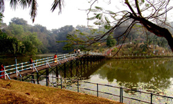
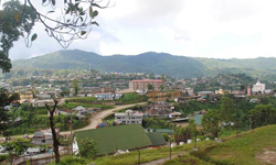
Shillong: The capital city of the State as well as the District Headquarter of East Khasi Hills district – Shillong is the only hills station in the country that is accessibly from all sides. The name Shillong is derived from U-Shyllong, a powerful deity and is built at an altitude of 1,491m above sea level. This beautiful city is 103 km, from Guwahati, the nearest air and train link. The presence of many well reputed educational institutions, many of them established by various missionary groups made Shillong the hub of education for the entire north-east.
Ward’s Lake, a beautiful manmade lake named after Sir William Ward, with short garden walks and boating facilities, this is a popular spot for both local and visiting tourists.
Lady Hydari Park, well manicured garden with a mini – zoo and children’s playground attached to it – this park right in the heart of the city is now run and managed by the Forest Department. Lies close to this park, the Crinoline falls and the city’s only swimming pool.
Capt. Williamson Sangma State Museum, for those interested in ethnic tribal culture and tradition this Museum offers insights to the lifestyle of the people. This Museum in the State Central Library Complex where monuments for the great patriots of the State had been erected besides the statues Smt. Indira Gandhi and Netajii Subash Bose. Besides the Govt. run museum there are also several museum run by other Department.
Golf Course is often compared to the Gleneagle of Scotland – Shillong golf-course is one of the oldest and best natural golf course in the world. Efforts are being made to upgrade this 18 hold course into international standard.
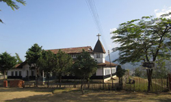
In the heart of the city, there stands beautiful Cathedral of Roman Catholics dedicated to Mary Help of Christian Surrounding the city there are numerous waterfall viz Elephant Fall in upper Shillong, Sweet fall of Happy Valley and the Bishop Beadon fall in Mawlai.
Dain-Thlen Fall is 5kms off the road just before reaching Cherrapunjee is the famous legendary Dainthlen falls where the evil serpent monster was killed. Close by the falls the spot from where the serpent was pulled out is still preserved. The whole areas above the falls present beautiful time worn aqua formations; the place is a popular picnic spot.
Noh-Kalikai Fall is another beautiful roaring waterfall in Noh-Kalikai, just 2 kms beyond the market place. This waterfall also has it legendary connected after Ka-likai committed suicide here to escape from the ill treatment of her second husband.
The majestic Noh Sngithiang Fall also known as Mawsmai fall cascade down from imposing height in numerous rivulets. This captivating cascade is about one km from Cherrapunjee.
Nartiang Monoliths: Monoliths exits throughout the length and breath of the Khasi and Jaintia Hills, the biggest collection of Monoliths or Megalithic stones in one single area is to be found north of the Nartiang market. Though Nartiang Village has the greatest number of monoliths found in the single area, at Nongbah there are two clusters of smaller proportion. One cluster can be found at lawmusiang Rim while another at Moorilung locality within Nongbah Village.
Umium Lake: More popularly known as Barapani, this is the biggest artificial lake in the state located about 17 km from Shillong. This is a very popular place for picnic, fishing and water sports. The Orchid Lake Resort here has water sports facilities and the nearby Loom Nehru Park has an aviary orchidarium.
Cherrapunjee: Cherrapunjee 56 kms from Shillong is literally the high point of any visit to Meghalaya. This is one of those ultimate eco-destinations, a place renowned the world over for having the privilege of receiving the highest rainfall in the world. Set against a backdrop of breathtaking beauty in its legendry landscape, it is inter-woven by gurgling mountain streams meandering their way through rocks and crevices dropping over sheer cliffs in cascading waterfalls in thunderous uproar into deep precipitous picturesque gorges. A place to discover the Indian Summer Monsoons, an unique annual meteorological phenomena directly influenced by the Southwest monsoon and the North East winds the heavy monsoon rains over these mountains perhaps create one of the rainiest biodiversity vegetation of the world. Truly an unique corner in North-East India just waiting to be discovered and explored. Cherrepunjee Sub-Division of the East Khasi Hills District is set upon a plateau on the southern slopes of the State. The swift flowing rivers and streams flow in a southernly direction to the plains. The narrow strip of land at the foothills runs along the International border of Bangladesh.
The old Cherra or Sohrarim was the original Cherra village but with the coming of the British who set up their headquarters further south of the village came to be known as ‘Sohra’ or present day Cherrapunjee. It was here that the British realized the enormity and intensity of the rainfall and set up a meteorological office for measuring of the same, which has now became known as the wettest place on earth.
The maximum rainfall occurs over the Southern slopes of the Khasi Hills in Cherrapunjee the highest recorded total annual rainfall was 24,553.3 mm in 1974. The maximum for a single day recorded in 1876 in Cherrapunjee, when 1,040 mm fell in 24 hours. Cherrapunjee also holds the World Records for a month’s rainfall when 9,300 mm fell in July 1861. Cherrapunjee was declared by the British to be the capital of Assam in 1832.it was latter, shifted to Shillong in 1866 due to the inclement weather of this place. A memorial stands as testimony to the contribution’s made by Mrs. Devid Scott at Cherrapunjee. Duwan Sing Syiem Bridge is the entrance of the Cherrapunjee tourist circuit. From here the landscapes abruptly changes into breathtaking beauty of a deep picturesque gorge.
Laitkynsew – Living Root Bridges can be found east of Laithynsew village on the hiking trail by cobbled stoned pathway through forested area down hill approximately one and a half hour walk from Laithynsew. 15 kms further from Cherrapunjee there is a holiday resort run by a private party. The resort offers visitors treks around the picturesque hills spring bath, the thrills of caving and any other forms of excitement.
Thangkharang Park – Managed and well maintained by the State Forest Department, this park on Mawsmai – Shella road about 8 kms from Cherrapunjee is a popular tourist spot. There are many rare and exotic orchids and some rare species of plants endemic to the area.
Caves:
Umiawan: Meghalaya has the maximum number of caves as well as the largest and longest in the Indian Sub-Continent. Some of these caves can be found in the Jaintia Hills. The sleepy hamlet of Lumshnong village came into limelight recently when it has been confirmed that the Umiawan cave situated in this village is the longest and also the deepest in he Sub-Continent. The Umiawan cave is interconnected with two other caves namely Kot-Sati and Umskor caves. The total length of these caves is more than 21 kms and about 100 m in depth. This place is 60 kms east from Jowai. Dotted across the entire district there are numerous caves and caverns wit spectacular stalagmites and stalactites formations. Till now only a few of these caves have been explored and surveyed.
Mawsmai: Just 6 kms from Cherrapunjee market to the south lies the village of Mawsmai in the direction of Bangladesh border. At the village crossing to the right, over the river passing monoliths (upright standing stones) continue along this road which passes across grassland surrounded by forest ending in a clearing. From this clearing a concrete pathway through the jungle leads up to the main cave entranced. This cave is the only cave that is fully lighted. The cave can be divided into two parts (old and new) of the two the new cave is yet to be lighted out had impressive formations of large passages and chambers.
Siju: 30 kms North of Baghmara and 132 kms from Tura. Siju is famous for Dobakkol or the bat cave with impressive stalagmites and stalactites. It is one of the longest caves in the Indian sub-continent and contains some of the finest river passages to be found any where in the world. The magnificent limestone rock formations inside especially named princess Die’s chamber by the excavators will fill any visitor with awe. Close by on the other side of Simsang river Siju birds sanctuary is the home for many rare and protected birds and other wildlife’s. The migratory Siberian ducks also come here during winter months. At the entrance to this bird sanctuary after a steep climb of nearly 1 km there is a stretch of fantastic rock formation that will take your breath away.
Krem Mawmluh: Approximately half km west of Cherrapunjee adjacent to the village Mawmluh, there is a beautiful cave with magnificent Stalagmites and Stalagtites, with a length of 4.5 kms. Access to the cave via the river, which lies to the south east of the Cement Factory of high deep water (low water conditions). The entrance is about 10 ft. above water level a single entrance leading to a double passage way where the upper portion in certain areas have caved in due to the intensive quarrying of limestone above the cave. The river enters the cave into pools of water within cave. This cave stretches for about 4,500 meters of passages with five river passages but marred by the population entering the cave from the cement factory locally known Krem, Mawmluh and is currently recognized as one of the longest cave in Indian subcontinent.